Wolverhampton to Tipton, Wednesbury Oak Loop & Ocker Hill Branch
Tipton to Wolverhampton including the
Wednesbury Oak Loop & Ocker Hill Branch
Flight along the route today (Wednesbury Oak Loop South)
Flight along the route today (Ocker Hill Branch West)
* Image colourised from black and white original
Three Furnaces Line


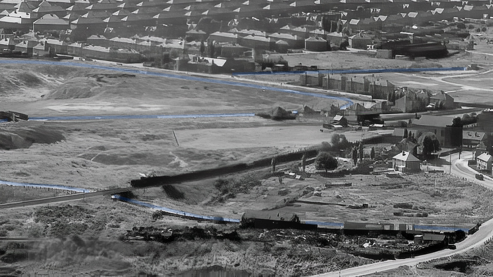
Three Furnaces Line 1935 (Britain from Above)

Three Furnaces Line Junction

Three Furnaces Line (Aerofilms)

Three Furnaces Line Junction 1965 (Ian Huselbee)

Three Furnaces Line 1937 (Britain from Above)

Three Furnaces Line 1935 (Britain from Above)
Wednesbury Oak Loop

1:25000 Ordnance Survey Map 1920's

Aerial View 1945 (Google Earth)
Bradley to Summerhill


Wednesbury Oak Loop Surviving Northern Section 1946 (Britain from Above)

Tup Street Bridge (Ron Davies)

Tup Street Bridge 1946 (Britain from Above)

Tup Street Bridge 1936 (Britain from Above)

Tup Street Bridge 1936 (Britain from Above)

Plan of Tup Street Bridge from the North 1954 (British Transport, CRT Archive)

Tup Street Bridge 1950 (Duncan Moore / RAF)

* South from Tup Street Bridge 1959 (Rodney Weaver RCHS)

Tup Street Bridge and Bradley 1949 (Britain from Above)

* Bradley Lane from Batman's Hill (John Whitehouse)

Tup Street Bridge and Bradley 1949 (Britain from Above)

* Batman's Hill Bridge

Batman's Hill Bridge and Rocket Pools 1949 (Britain from Above)

* Batman's Hill Bridge

Weddle Wynd and Bradley Locks 1945 (Google Earth)

Weddle Wynd and Rotton Brunt Line 1949 (Britain from Above)


* Across Weddle Wynd looking South, canal beyond mown grass (Paul Ratcliffe)

Rotten Brunt Shortening 1949 (Britain from Above)

* Rotten Brunt Embankment (Richard Chester Browne, BCNS)

* Bradley Junction and Howls Bridge 1958 (Roy Salter)

Bradley Junction to Howls Bridge (BCNS)

Weddle Wynd 1939 (Britain from Above)

Bradley Locks, Wednesbury Oak Loop, Gospel Oak & Ocker Hill Branch (Britain from Above)

Bradley Junction (Vic Smallshire)

Wednesbury Oak 1949 (Britain from Above)

* South to Howls Bridge 1960 (Brian Beagley)

Whole line South from Bradley Junction (Britain from Above)

* Bradley Junction from Howls Bridge 1952 (HNBC Philip Weaver)

Rotton Brunt Line from Howls Bridge (Vic Smallshire)

Howles Bridge 1965 (Ian Huselbee)

* Partridge Bridge 1952 (HNBC Philip Weaver)

Partridge Bridge 1965 (Ian Huselbee)

* Gospel Oak or Coxs Bridge 1973 (Keith Hodgins)

Gospel Oak Bridge 1965 (Ian Huselbee)

Gospel Oak or Coxs Bridge (Vic Smallshire)
Railway Bridge and Princes End 1949 (Britain from Above)

Railway Bridge 1965 (Ian Huselbee)

Railway Bridge 1965 (Ian Huselbee)

Princes End 1949 (Britain from Above)

Glebefields Bridge 1960 (Michael Hale, Keith Hodgkins)

* By Upper Church Lane 1952

* Summerhills looking North by Upper Church Lane 1952 (HNBC Philip Weaver)

* Princes End approaching Lathes and Upper Ocker Hill Branch 1952

Princes End approaching Lathes (BCNS)

* Princes End, Lathes near Upper Ocker Hill Branch 1957 (Frank Power, Keith Hodgkins)

* St John's Church, Upper Church Lane 1950's

* Junction with the Upper Ocker Hill Branch 1952 (HNBC Philip Weaver)

* Looking North West from the junction bridge to Lathes (Keith Hodgkins Collection)
Upper Ocker Hill Branch


Ocker Hill Branch 1945 (Google Earth)
* Junction with the Upper Ocker Hill Branch 1952 (HNBC Philip Weaver)

* Looking East from Junction Bridge 1952 (HNBC Philip Weaver)

* Looking West under the Junction Bridge (Keith Hodgkins)

Upper Ocker Hill Branch West 1949 (Britain from Above)

Ocker Hill Branch 1949 (and Bradley Locks / Gospel Oak Branch at bottom) (Britain from Above)

* West from Moat Bridge 1940s

* East from Moat Bridge towards the Pumping Station 1898

* East from Moat Bridge towards the Pumping Station 1930

Upper Ocker Hill Branch West 1949 (Britain from Above)

* Looking West near Stepping Bridge 1952 (HNBC Philip Weaver)

* Embankment and Stepping Bridge

* Stepping Bridge and Works 1952 (HNBC Philip Weaver)


* Ocker Hill Depot

* Stepping Bridge

* "Bird" at Ocker Hill Depot 1938 (TW King)

* "Atlantic" at Ocker Hill Depot 1952 (HNBC Philip Weaver)

* Ocker Hill Works 1952 (Rodney Weaver RCHS)

* Ocker Hill Works 1952 (Rodney Weaver RCHS)

* The Pumping Engine 1952 (HNBC Philip Weaver)
Summerhill to Bloomfield


Parker Bridge 1949 (Britain from Above)

Summerhill 1950 (Britain from Above)

Summerhill to Bradley 1950 (Britain from Above)

* North East from Summerhill Bridge, Ocker Hill Branch Behind 1955 (Bill Bawden)

* Summerhill Bridge (Rodney Weaver RCHS)

Tibbington 1966 (Aerofilms)

Tibbington 1949 (Aerofilms)

Bloomfield (right) to Bradley (left) Central Ave. Aqueduct (centre) 1950 (Britain from Above)


Central Avenue Aqueduct (Tipton & Black Country Group)

Footbridge by Central Avenue Aqueduct 1966 (Ian Huselbee)

Site of the Central Avenue Aqueduct 2017 (Keith Hodgkins)

Central Avenue Aqueduct 1950 (Britain from Above)

Footbridge and Central Avenue Aqueduct 1966 (Ian Huselbee)
Central Avenue Aqueduct to Bloomfield (Britain from Above)

To Bloomfield 1937 (Britain from Above)

3 Furnace Line 1931 and Tibbington (Keith Hodgkins)

Tipton Green and 3 Furnace Line 1931 (Britain from Above)

* Tipton Green and 3 Furnace Line

Tibbington (Keith Hodgkins)

Bloomfield 1961 (Aerofilms)

Railway, Iron Works Basin, Bloomfield Road (Paul Smith Collection)

Bloomfield 1949 (Aerofilms)

East from Bloomfield Road (Keith Hodgkins)

East from Bloomfield Road (Keith Hodgkins)

East from Bloomfield Road and Brymills (Keith Hodgkins)

* Bloomfield Road Bridge 1958 (Arthur Watts CRT Archive)

Railway from Bloomfield Road 1965 (Ian Huselbee)

* Looking West from Bloomfield Road 1958 (Arthur Watts CRT Archive)

Looking East to Bloomfield Road from the Railway (Vic Smallshire)

Bloomfield 1949 (Aerofilm)

* Railway Bridge next to Bloomfield Road Bridge 1958 (Arthur Watts CRT Archive)

* From the Railway West to Bloomfield Interchange Basin 1958 (Arthur Watts CRT Archive)

* Looking West by Bloomfield Interchange Basin 1958 (Arthur Watts CRT Archive)

Bloomfield Basins from the Railway 1965 (Ian Huselbee)

From basin bridge looking East (George Smallshire, DCTT)

* Opposite Bloomfield Interchange Basin 1958 (Arthur Watts CRT Archive)

* Bloomfield Interchange Basin Towpath Bridge 1968 (Alan Price)

Bloomfield Interchange Basin Towpath Bridge (Vic Smallshire)

Bloomfield Interchange Basin looking back to the entrance (Vic Smallshire)

Bloomfield Interchange Basin (Vic Smallshire)

Bloomfield Interchange Basin (Vic Smallshire)

Bloomfield Interchange Basin (Vic Smallshire)

Bloomfield Interchange Basin (Vic Smallshire)

Bloomfield Interchange Basin (Frank Powers)

Bloomfield Interchange Basin (Lawrence Brownhill, Keith Hodgkins)

* Railway Bridge immediately before Bloomfield Junction 1958 (Arthur Watts CRT Archive)

* Bloomfield from the train 1948 (Conurbation, Paul Redmayne)

* Railway Bridge from Bloomfield Junction 1958 (Arthur Watts CRT Archive)

Bloomfield Junction from Railway (George Smallshire, DCTT)


* Bloomfield Junction 1965

Bloomfield Junction from North (George Smallshire, DCTT)
Hurst Hill Branch

Hurst Hill Branch 1946 (Britain from Above)

Hurst Hill Branch 1946 (Britain from Above)
Spring Vale Area


Ladymoor Branch 1946 (Britain from Above)

Ladymoor Branch 1926 (Britain from Above)

Parkfield Branch 1948 (Britain from Above)

Parkfield Branch

Parkfield Branch 1946 (Britain from Above)

Parkfield Branch 1946 (Britain from Above)

Spring Vale Branch 1936 (Britain from Above)

* Spring Vale Branch

* Spring Vale Branch

* Spring Vale Branch

* Spring Vale Branch

* Spring Vale Branch

* Spring Vale Branch 1904

* Spring Vale Branch (Wolverhampton Archives)

Bilston Colliery Branch 1936 (Britain from Above)

Bilston Colliery Branch 1936 (Britain from Above)
Wolverhampton Area
Horseley Fields Area


Commercial Wharf 1932 (Britain from Above)
.JPG)
Commercial Wharf (Wolverhampton Archives)
.JPG)
Commercial Wharf (Wolverhampton Archives)

Commercial Wharf (Arthur Farrand Radley, BCNS)


Minerva Wharf 1932 (Britain from Above)

* Minerva Wharf 1947 (Hugh Potter)

* Minerva Wharf 1968

* Minerva Wharf

Minerva Wharf 1932 (Britain from Above)

Minerva Wharf (Aerofilms)
Victoria Basin


Victoria Basin 1924 (Britain from Above)

Victoria Basin 1924 (Britain from Above)

* Victoria Basin

* Victoria Basin
These images are reproduced for ease of research are are not the property of this blog, and as such should
not be used for commercial gain without the explicit permission of the owner (whoever that may be).


Comments
Post a Comment